A tool to support local clean heat planning
 www.nesta.org.uk/project-updates/a-tool-to-support-local-clean-heat-planning/
www.nesta.org.uk/project-updates/a-tool-to-support-local-clean-heat-planning/
www.nesta.org.uk/project-updates/a-tool-to-support-local-clean-heat-planning/
The UK's current approach to low-carbon heating relies primarily on individual household decisions supported by government incentives. Nesta’s clean heat neighbourhoods team is working on approaches that facilitate local low-carbon heat delivery and the transition of multiple households within the same geographic area. We gathered feedback from external stakeholders on our map of heat pump suitability in Great Britain (GB) and worked closely with Plymouth City Council to understand whether granular heat planning could enable delivery.
We are now expanding on previous work and building a tool to support local areas in:
Our hunch is that this will help to bridge the gap between strategic energy planning and local delivery of low-carbon heating solutions in Plymouth and create a replicable approach for other areas in GB. The supply chain and local stakeholders are fundamental in determining deliverable schemes. Our aim is that the tool will support and expedite the work of others.
Currently, this tool is being prototyped, alongside our work in Plymouth, with the aim of being replicated in other local areas across GB. As such, and since different local authorities have different needs, we’re keen to work closely with local governments across GB to test the methodology and assumptions about the value, feasibility and replicability of this work. If you work in a strategic, mayoral or local authority reach out to speak with us at [email protected].
In the following months, we will build this tool and develop a methodology, driven by user needs. We will work closely with local authorities to:
Below we describe the work in more detail, although some of the methodology and approach will likely change or adapt as we continue to work on delivering this tool. Data underlying this work will be sourced from openly available datasets such as Ordnance Survey, the energy performance certificates register and government public datasets.
Identifying the most suitable low-carbon heating technology for each home or small area is a complex task that requires both human knowledge and insights delivered by robust data modelling and analysis.
Properties will initially be grouped into one of the following four main categories of low-carbon heating technologies:
We will apply this to the work testing a clean heat plan in Plymouth to:
The models we build will then be used to identify the most suitable low-carbon heating for each property or group of similar properties. Where it exists, the UK government’s Department for Energy Security and Net Zero’s heat network zoning will be used to identify groups of properties suitable for heat networks. The manually labelled areas can be used for early evaluation of the models we build.
The images below represent fictional examples of how we could visualise groups of properties, where each colour represents a different low-carbon heating solution.
Orange - Individual heat source; Green - Shared ground loops; Pink - Communal heat source.
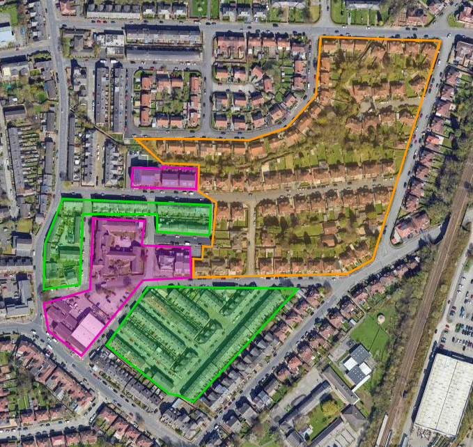
Figure 1. Fictional representation of how groups of properties can be visualised, where each colour represents a different low-carbon heating solution. It's not meant to be an accurate representation of how properties could be grouped and categorised.
The orange section comprises properties with ample outdoor space for an individual air source heat pump unit. The green consists of denser, residential properties, a mix of flats and back-to-back terraces. The pink areas are a mix of blocks of flats and dense houses, close to anchor loads such as schools, which may lend this group of properties to another communal type of heating, such as a communal heat network. Anchor load properties are large properties that provide a reliable high demand for heat, making heat networks more economically viable solutions. These can include: schools, universities, hospitals and major retail stores.
Properties will be grouped together into clusters (which vary in size). This might originally result in very small clusters (even clusters of a single property), as per the coloured areas highlighted in the image below, which can then be merged into bigger groups of properties (the coloured areas in the image above).
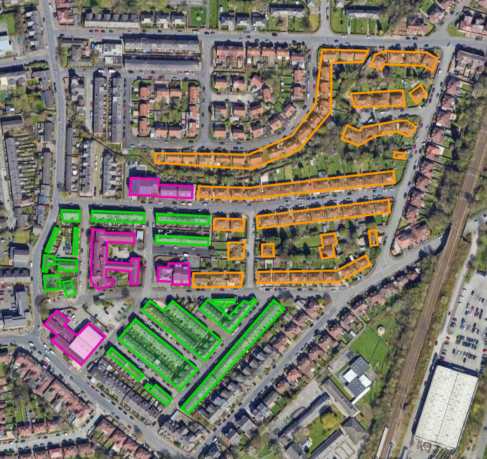
Figure 2. Fictional representation of visualising clusters of properties, where each colour represents a different low-carbon heating solution. It's not meant to be an accurate representation of how properties could be grouped and categorised.
After properties are grouped into clusters and merged (where applicable), contextual information will be layered on top to provide relevant information about properties and households within a cluster as well as the surrounding area. The aim of providing contextual information is to support decision-making. Examples include:
The information that enables decision-making will be identified through user testing with a variety of local authorities and stakeholders in the supply chain.
In the next few months we will be building this tool using an iterative approach driven by user needs. We are interested in testing the underlying methodology and assumptions about the value, feasibility and replicability of this work in other areas. If you work in a strategic, mayoral or local authority and are curious to learn more, reach out by contacting [email protected].
Nesta: Roisin Gorman, Simon Jarrett, Rachel Murphy, Sofia Pinto, Andy Marsden
Plymouth City Council: Lucinda Brook, Ciara Longley, Jon Selman, Nicola Turvey


